Glacial Geomorphology - Erosion & Deposition
GLACIAL MECHANICS: THE PHYSICS OF EROSION
A glacier and its surroundings should not be treated as a simple heightfield with a noise texture. It must be understood as a geological fluid that carries an immense mass. Over tens of thousands of years these bodies of ice grind, crush, and polish entire mountain ranges and therefore leaving behind a specific topographic signature.
This chapter focuses strictly on the mechanical interaction between ice and bedrock, and understanding them is crucial for creating correct details, such as creating polished valley floors aswell as depicting the specific fracture patterns of a cliff face.
THE NATURE OF FLOWING ICE
Glacial ice behaves as a hybrid material: at the granular scale it is crystalline and brittle, but at the macroscopic scale of a valley it flows like a high-viscosity fluid. This creates a thick and extremely heavy plastic mass that is defined by rounded undulations, capped by a fractured upper crust. This fracturing occurs because the brittle surface ice cannot stretch fast enough to match the plastic flow of the deep core, tearing open into tension cracks known as Crevasses.
The movement of this mass is driven by two distinct physical forces. First, Internal Deformation occurs when the ice warps under its own immense weight, which lowers its melting point. Second, Basal Slip occurs when the glacier decouples from the ground and slides on a thin film of water beneath it. When the glacier is sliding on top of the bedrock the terrain will be permanently reshaped.
WARM VS. COLD BASED GLACIERS
It is critical to understand that not all glaciers erode the land. The Thermal Regime (the temperature of the ice at the bed) determines the erosional potential.
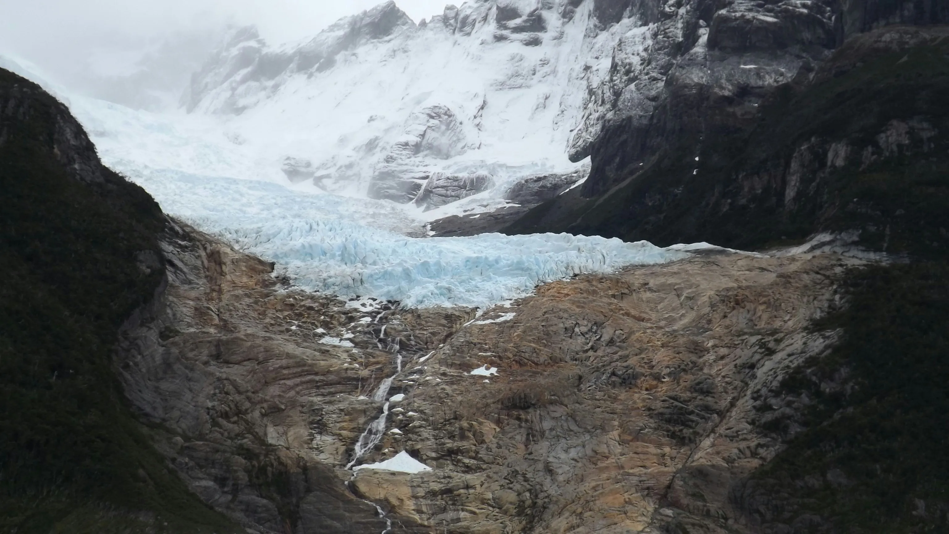
Warm-Based Glaciers In temperate regions (like the Alps or Rockies), the pressure of the overlying ice lowers the melting point at the base. This creates a thin film of water between the ice and the bedrock. This water acts as a lubricant, allowing Basal Slip. The glacier decouples from the ground and slides, dragging rock and debris with it. If your terrain features polished granite, striations, or deeply carved U-shaped valleys, you are visualizing a warm-based system.
Cold-Based Glaciers In polar regions the ice is frozen solid to the bedrock, which means there is no water film. The glacier moves solely by Internal Deformation, so it is warping under its own weight (similar to putty). Because it does not slide along the ground, it does not erode it. These regions preserve pre-glacial features such as ancient permafrost polygons or the wind-carved snow ridges called Sastrugi.

MECHANISMS OF WEAR
ABRASION
Abrasion is the slow grinding of the bedrock by debris that is frozen into the glaciers mass. It follows along the glaciers movement, and transform the ground beneath it.
- Polishing: Fine-grained silt acts as a polishing agent and is grinding hard granite or gneiss until it is so smooth that it even reflects light.
- Striations & Grooves: Larger embedded stones cut straight and parallel scratches, while massive boulders carve very deep grooves. These lines must always align with the direction of the ice flow.
- Rock Flour: This process pulverizes rock into a microscopic powder that, when suspended in meltwater, creates a “flour”, which is responsible for the milky turquoise color that is characteristic of glacial lakes.
PLUCKING
While abrasion smooths the landscape, Plucking destroys it. Pressure-melted water flows into natural fractures in the bedrock and refreezes. As it freezes, it expands by approximately 9%, shattering the stone. The moving glacier then “plucks” these loosened blocks from the ground and drags them with it, where they will cause further abrasion further down the line.
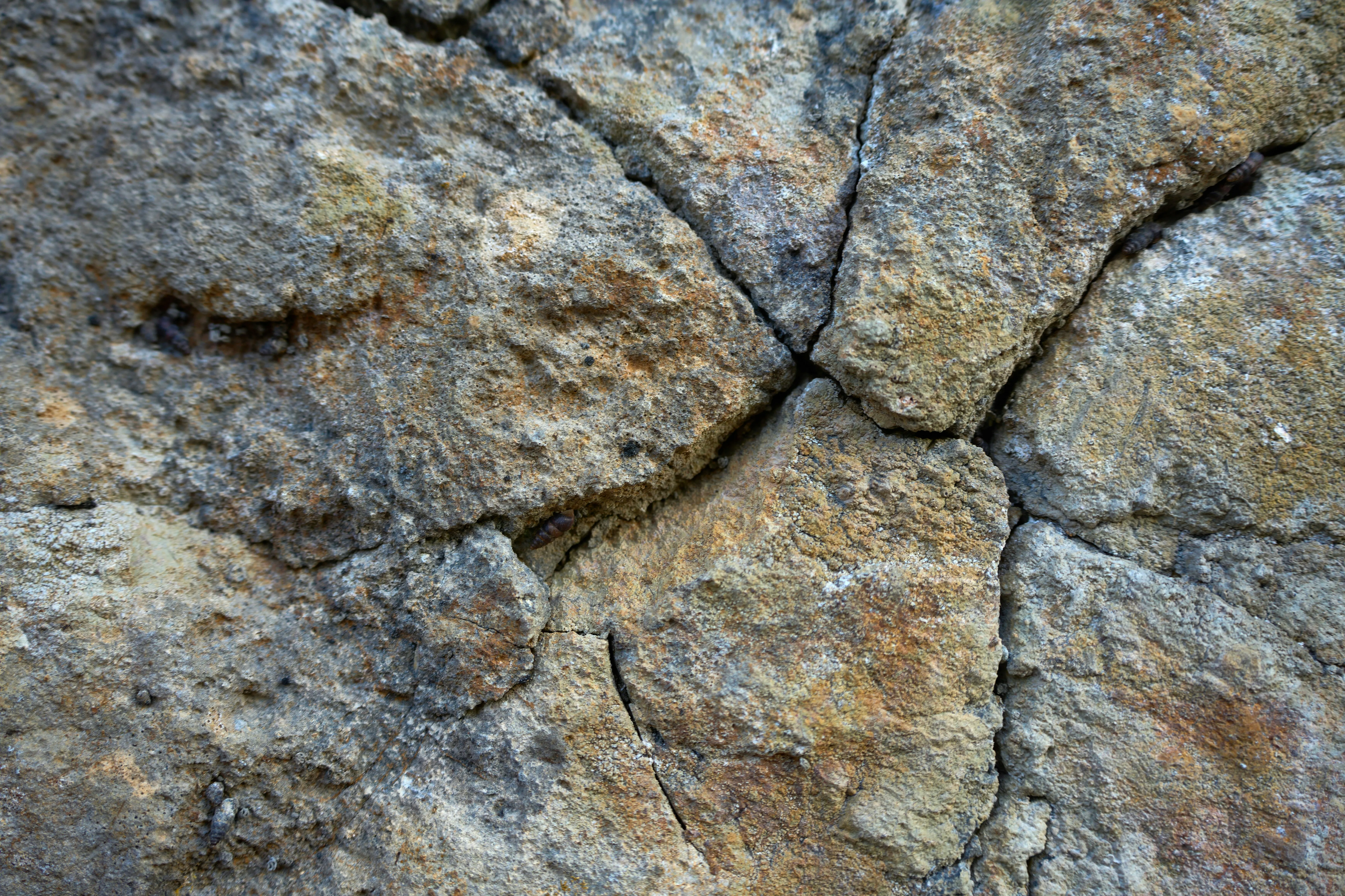
FREEZE–THAW WEATHERING
At the edges of the glacier (specifically on the cliffs above the ice) the landscape is torn apart by a cycle called Frost Shattering. Water enters the rocks’ cracks, freezes, and then splits the rock. This fracturing primes the terrain for erosion by breaking the rock apart before the glacier even touches it.
The process is most visible on the cliffs above a cirque or along the borders of U-shaped valleys, so the headwalls should appear jagged and vertically fractured, while the valley floor is smooth and eroded. The shattering process creates aprons of freshly broken rock known as Talus Slopes which accumulate beneath the cliffs and feed the glacier with new debris that will contribute to more abrasion.
EROSION
These physical forces combine to create specific forms that an artist should be able to spot in references and properly recreate them.
ROTATIONAL SLIP
Glaciers carve their own birthplaces through a process called Rotational Slip. Instead of sliding straight down a slope, the ice in the accumulation zone rotates backward, which acts like a geological scoop that gouges out a deep and amphitheater-shaped basin known as a Cirque.
The resulting terrain features a steep vertical backwall and a raised rock threshold at the front where the erosion was less intense. When the ice retreats the raised lip acts as a natural dam, trapping meltwater inside the basin which will then form a circular mountain lake known as a Tarn.
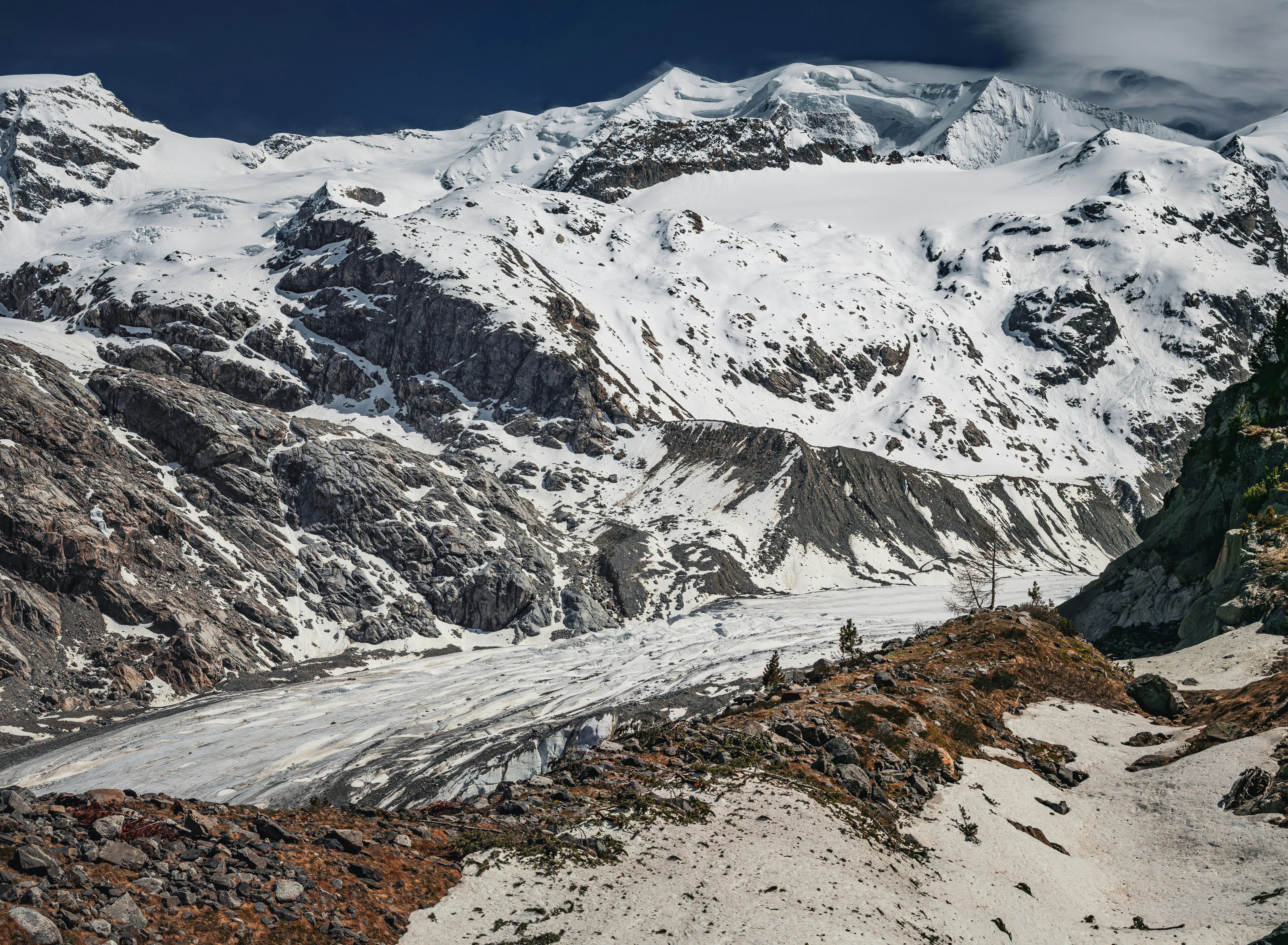
VALLEY TRANSFORMATION (V TO U)
The strongest visual indicator of glaciation is the cross-section of the valley. Rivers carve narrow “V” shapes, while glaciers reshape the landscape through volumetric erosion. This process is removing material from the floor and walls simultaneously, and the result is a U-Shaped Valley (Glacial Trough). It is defined by a broad, flat floor and nearly vertical walls.
- Truncated Spurs: As the glacier plows through a winding river valley, it shears off the ends of interlocking ridges. It is leaving behind triangular cliffs lining the valley walls.
- Hanging Valleys: Tributary glaciers often cannot erode as deeply as the main glacier. When the ice melts, their valleys are left stranded high on the cliff walls, creating waterfalls that plummet into the main trough

The Roche Moutonnée
The interaction of abrasion and plucking creates asymmetric bedrock knobs called Roche Moutonnées, which are essential for indicating flow direction in a scene without ice.
- Stoss Side (Upstream): Smooth, rounded, striated (Abrasion)
- Lee Side (Downstream): Steep, blocky, shattered (Plucking)
Deposition
Glaciers are conveyor belts for rock. Unlike rivers (which sort material by size), glaciers dump everything together in an unsorted mix called Till, which they will leave behind with specific signature when they retreat.
Moraines
Moraines are ridges of till that delineate the geometry of the vanished glacier.
| Type | Location | Characteristic |
|---|---|---|
| Lateral Moraine | Valley Sides | Sharp embankments running along the valley walls and marking the height of the ice. |
| Medial Moraine | Valley Center | Dark stripes running down the center of the valley (or glacier). Formed where two tributary glaciers merged. |
| Terminal Moraine | Valley Floor | An arc-shaped ridge acting as a dam. It marks the furthest point the glacier reached before melting back. |
Sub-Glacial Landforms
Some features form beneath the ice and are only revealed after the glacier vanishes.
Drumlins These are teardrop-shaped hills made of sediment (not bedrock). They usually form in swarms and look like frozen waves flowing across a plain, and feature unique shapes: blunt end points upstream (where the ice came from), and the tapered tail points downstream.
Eskers Winding ridges of stratified gravel. These are fossilized beds of sub-glacial rivers that flowed inside tunnels at the base of the ice, and upon melting the riverbed is laid down on the ground.
Erratics Giant boulders dropped in foreign landscapes. They are visually distinct because their rock type often does not match the ground they sit on (eg. a granite boulder sitting on a limestone plateau).